A violent beginning — Mt Canobolas erupted over a period of about a million years in the mid to late Miocene epoch 13 to 11 million years ago and the province covers ~825 km2 and radiates some 30 to 50 km from the summit of 1,397 m altitude.
Mt Canobolas is a prominent ‘landlocked island’[inselberg] protruding up to half a kilometre above the surrounding plateau of the western Central Tablelands. Mt Canobolas lies in the north eastern sector of the ancient Lachlan Fold Belt, specifically in its eastern sub-province. The belt, which had its origin along the margins of Gondwana, in a subductional setting, is composed mainly of deformed Palaeozoic deep-marine sedimentary rocks and mafic volcanic rocks. Throughout the province step-wise deformation and metamorphism involved folding, rifting, intrusion, faulting and uplifting which occurred during major tectonic events from the Silurian to Early Carboniferous epochs. The resulting palaeoplain underwent extensive erosion during a tectonically quiescent period, providing the sediments of the Sydney Basin. Subsequent rifting associated with the opening of the Tasman Sea and warping from its separation with the Great Divide together with Tertiary volcanism drastically changed drainage patterns east and west of the new divide. At the same time the Murray Darling Basin began to subside to the west. Three episodes of volcanism during the Tertiary period affected the warped, partly tilted and eroded palaeoplain; the most recent of these being the Canobolas Province.
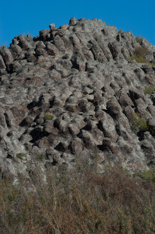
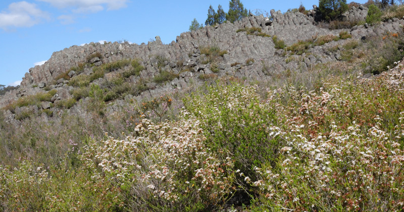
The prominent feature seen today is the eroded cone remnant of a compound shield volcano; a result of Tertiary volcanism associated with The Mount Canobolas Volcanic Complex. During the Tertiary period the Australian continental plate, as it drifted northward, passed over hotspots of lava pools in the earth’s mantle creating a chain of volcanoes, resulting in a succession of volcanic formations along the eastern highlands of Australia. Mt Canobolas is considered to be the southernmost and youngest of the age-progressive volcanoes along the purported inland track which extends from Main Range in southeast Queensland south through the Nandewar and Warrumbungle provinces to Canobolas. Extensive and violent eruptive episodes occurred over about ± 1 million years in the Middle to early/Late Miocene, between 13 to 11 million years before present. Lava and pyroclastic material from that era mostly cover the pre-Tertiary highly weathered palaeoplain landscapes within about a 20 to 50 km radius. The Canobolas volcanic complex initially produced large outpourings of basic lava. Trachyte kindred rocks predominate in the central complex, interlaced with a variety of volcaniclastics, with hawaiite on the outer edges. Thus there are large quantities of agglomerate and tuff associated with the various lava flows. The central elevated area consists of cones, plugs, domes and dykes and throughout the eruptive duration subsidence juxtaposed many rocks of different ages.
Following the Miocene volcanism an extended erosional phase continues to lower the landscape, reducing and fragmenting prior alpine and sub-alpine areas with resultant isolation of pockets on high peaks, such as Mt Canobolas. This is also being exacerbated by the Australian Continental Plate’s slow drift northwards into the tropics. Today the Canobolas province covers ~825 km2 radiating from the summit of 1,397 m altitude. Subsequent alluvium deposits in the landscape sometimes overlay lava flows in infilled drainage lines and elsewhere aeolian deposits have formed on rises, covering lava flows.
Mt Canobolas has important geoheritage value as geologists regard it as a national example of ‘shield’ volcanism. The complex is dominated by intrusions, plugs and domes, with Old Man Canobolas, Young Man Canobolas, Towac Pinnacle and Watt’s Pinnacle being among the more than 50 such provincial features. These main volcanic vents ceased activity at different times, with the core at the summit of Mt Canobolas being the youngest and because of evolution of the magma chamber between eruptions, seven main lava types are recognised.
Geomorphologically it is thus a relatively young constructional landform set in and spreading over a much older ancient landscape, so has global as well as regional and national significance. The visual and aesthetic prominence of the mountain have long been noted and admired but its geo-conservation value has been recently ignored.
In 1983 “The Mount Canobolas Volcanic Complex”, Towac Way, Canobolas NSW, Australia was registered under the National Estate. The Register of the National Estate was frozen in 2007 preventing the addition or removal of places. Seemingly the Complex was not renominated for consideration in the interim period for protection under any other statutory list or local government heritage register, and the National Estate Register’s statutory basis has elapsed.
Given that the mountain is not categorically protected from disturbances such as mining exploration for example, it is warranted to submit that the geoheritage values of the volcanic remnant formations, of world standard, be formally recognised and better conserved from any threats. The distinct geomorphic significance should not be in doubt or overlooked as a part of Australia’s geoheritage. It is therefore of concern that scenic, cultural and geoheritage values of the Mt Canobolas landscape are not being fully appreciated or formally recognised, despite their high significance.
Read more about the Geology of Mt Canobolas, Orange Regional Museum
Say NO to Mountain Bikes in Mt Canobolas State Conservation Area!
