Submission CCA submission to NPWS mountain biking strategy jan 2022
Mt Canobolas SCA occupies an area of 1,672 ha and is located approximately 15 km south west of Orange in the Central West of New South Wales. The Mount Canobolas State Conservation Area (the SCA) is part of the State’s Conservation Estate which reserves land in order to protect and conserve significant ecosystems, landforms, biodiversity and places of cultural significance. State Conservation Areas differ from other areas in the State’s Conservation Estate, such as National Parks and Nature Reserves, in that mineral and petroleum exploration and mining may be permitted. SCAs also provide opportunities for sustainable visitation, public enjoyment and research.
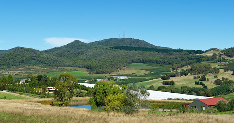
The whole of this SCA is situated on an extinct volcano, provincially known as The Mount Canobolas Volcanic Complex. Its mountainous terrain ranges in altitude from approximately 900 m to 1,397 m at the summit with a number of peaks, steep valleys and waterfalls. It is surrounded by the highlands of the extensive Central Tablelands plateau, having variable reliefs of up to 1,000 m altitude, dipping away to the west into the Central Western Slopes. The boundary between the CT and CWS is an undulating series of erosional step-down scarps.
When white settlers arrived in the Orange district, sub-alpine woodlands on fertile basaltic soils derived from Mt Canobolas occupied up to 850 km2 of undulating plateau above 800 m altitude from Orange almost to Blayney. Most of those rich volcanic soils have been cleared for agrarian and other production purposes. The SCA is the only conservation reserve on soils derived from the Canobolas volcano and represents less than three percent of the original basaltic woodland vegetation. Consequently, the SCA is a small remnant within a highly modified landscape of intensive silviculture, horticulture and extensive agricultural grazing pursuits.
Within the SCA, ecosystems have largely survived intact having been subjected to minimal clearing, light grazing and intermittent controlled burning. Wildfires, the most recent being February 2018, have been infrequent due to the sub-alpine environment.
Situated on the western boundary of the CT, the area is separated from coastal drainage by the Great Divide, approximately 85 km to the east. The western CT can be regarded as a western trending spur of the Great Dividing Range. The so-called Canobolas Divide is a north-west trending range and passes through the centre of the SCA, forming the watershed and dividing the inland drainage of the northern Macquarie-Darling River system from the southern Lachlan River system. Most drainage within the SCA is by first and second order streams.
